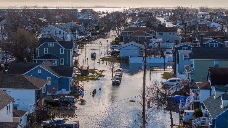
Flood risk has shifted from a secondary concern to a central issue in New York real estate transactions. Today, flood zone classifications directly affect financing, insurance costs, property value, and long-term ownership viability. As a result, buyers can no longer afford to treat flood exposure as an issue discovered late in the process.
Across Long Island and New York City’s waterfront neighborhoods, flood risk now shapes how transactions are structured and, in some cases, whether a purchase remains financially viable at all. Therefore, understanding flood exposure under New York law has become a critical part of informed real estate planning.
How Flood Zones Affect New York Real Estate Transactions
FEMA designates flood zones through Flood Insurance Rate Maps (FIRMs), and lenders rely heavily on these classifications. Consequently, a property’s flood zone status often determines whether flood insurance is required and how costly that coverage will be.
In practice, flood zone classification can affect:
- Whether lenders require flood insurance
- Annual insurance premiums under FEMA’s Risk Rating 2.0
- Eligibility for federally backed mortgage loans
- Long-term carrying costs and resale value
Unfortunately, many buyers only learn that a property sits in a flood zone after signing a contract. Often, this discovery occurs during lender underwriting or insurance review. As a result, buyers may face renegotiations, financing delays, or even deal termination.
South Shore Long Island: Elevated Risk & Rising Costs
The South Shore of Long Island contains some of the highest-risk flood zones in New York State. Neighborhoods along and south of Merrick Road—including Freeport, Baldwin, Merrick, Bellmore, Wantagh, Seaford, Massapequa, Amityville, and Lindenhurst—frequently fall within AE or VE flood zones.
In these areas, federally backed mortgages typically trigger mandatory flood insurance requirements. Moreover, FEMA’s Risk Rating 2.0 calculates premiums on a more individualized basis. As a result, insurance costs now reflect elevation, proximity to water, and construction features, making premiums higher and less predictable.
For buyers and investors, flood insurance on Long Island has therefore become a core underwriting consideration rather than a closing-stage detail.
Brooklyn Waterfront Neighborhoods
Brooklyn presents many of the same flood-related challenges seen on Long Island’s South Shore. Neighborhoods such as Red Hook, Gowanus, Williamsburg, Greenpoint, Sheepshead Bay, and Coney Island include substantial areas within designated flood zones.
Because flood exposure varies widely by building, buyers must evaluate several factors early in the transaction, including:
- FEMA flood zone classification
- Flood insurance availability and cost
- Existing mitigation measures, such as elevation or floodproofing
- Lender requirements tied to climate risk
In older waterfront buildings, flood insurance premiums often reduce rental returns and weigh heavily on long-term resale value. Consequently, flood risk plays a direct role in pricing and investment strategy.
Lower Manhattan: Vertical Living Does Not Eliminate Risk
Flood zones continue to influence real estate planning in Lower Manhattan, including the Financial District, Battery Park City, and portions of the Lower East Side.
Although developers increasingly incorporate flood-resilient design, flood exposure still affects many properties. For example, insurance requirements may apply to basements, mechanical systems, storage areas, or common elements. Therefore, buyers should not assume that high-rise construction eliminates flood risk entirely.
From a legal and financial standpoint, flood exposure now affects financing terms, insurance obligations, and long-term asset planning—even in premium Manhattan markets.
Queens & Jamaica Bay
Neighborhoods surrounding Jamaica Bay—such as Howard Beach, Broad Channel, Rockaway Park, and Far Rockaway—rank among the most flood-prone areas in New York City. Transactions in these areas often require heightened due diligence. Additionally, mandatory flood insurance in these neighborhoods continues to rise in cost, directly affecting affordability and ownership planning.
Staten Island Coastal Areas
Staten Island’s South Shore and East Shore remain particularly vulnerable to storm surge and coastal flooding. Neighborhoods such as Great Kills, Midland Beach, South Beach, and Tottenville frequently fall within designated flood zones. Because flood exposure can trigger additional lender requirements, buyers benefit from addressing insurance and long-term cost planning early in the transaction process.
How Flood Risk Impacts Real Estate Deals
Flood insurance no longer represents a niche concern. Instead, flood exposure now plays a meaningful role in nearly every stage of a New York real estate transaction. Specifically, flood risk can affect:
- Mortgage approval and loan terms
- Monthly and long-term ownership costs
- Disclosure obligations and potential liability
- Resale value and exit strategy for investors
When buyers fail to assess flood risk early, transactions may derail or impose unexpected financial strain after closing.
Planning Ahead
Ultimately, understanding flood zones and insurance requirements has become a fundamental part of responsible real estate planning in New York. Buyers and investors should review FEMA flood maps, insurance obligations, and long-term climate exposure before signing contracts. With proper planning and early review, buyers can identify and address flood-related risks in advance through informed negotiation, pricing adjustments, or strategic structuring.
This blog is for informational purposes only and does not constitute legal advice.